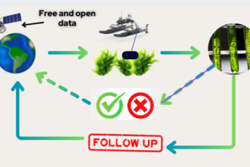
Optimized Data Integration for Greater Accuracy
Instead of relying solely on algal coloration, we analyze satellite bands that correspond to key environmental factors influencing algal growth. By combining data from multiple satellite databases, we reduce resolution-based errors and enhance detection accuracy. This approach allows us to pinpoint areas with the highest natural proliferation potential, optimizing our search and resource allocation.
Landsat-8.
The Landsat-8 satellite is part of the Landsat mission of NASA and the U.S. Geological Survey (USGS). It was launched in 2013 and aims to provide high-resolution images of the Earth’s surface.
- Usefulness for the project: Landsat-8 provides images in multiple spectral bands (including near infrared), which is ideal for detecting water bodies, algae and changes in vegetation. Its spatial resolution is 30 meters, which allows monitoring large areas at a regional level.
- Passage frequency: Every 16 days, which offers a good frequency for monitoring algae zones.

Sentinel-2
Sentinel-2 is part of the Copernicus program of the European Space Agency (ESA) and was launched in 2015. This mission has two satellites (Sentinel-2A and Sentinel-2B), which provide high-resolution optical images.
- Usefulness for the project: Sentinel-2 has a spatial resolution of up to 10 meters in some bands, making it ideal for monitoring coastal areas and bodies of water. Its 13 spectral bands, including infrared, are excellent for detecting the presence of algae and assessing their concentration.
- Frequency of passage: Images are available at a frequency of 5 days, which facilitates frequent monitoring of selected areas.

Sentinel-3
Also part of ESA’s Copernicus program, Sentinel-3 was launched in 2016 and is designed to monitor the Earth’s surface, oceans and atmosphere.
- Project utility: Sentinel-3 has a spatial resolution of 300 meters in some of its bands, but excels in measuring ocean parameters, such as sea surface temperature, salinity and chlorophyll concentration (indicative of algal biomass). Its data are crucial for monitoring the state of marine areas and their ecosystems.
- Frequency of passage: It has a coverage frequency of 1-2 days, allowing constant observation of coastal and oceanic areas.

0 Comentarios